Tag Archive for: echo park history

Yes, we love maps – especially old ones of Echo Park and Los Angeles. The latest publication on the Big Map Blog is a nice display of Los Angeles circa 1903, so we zoomed in nice and close on Echo Park (of course!).

The map shows a sprinkling of homes with lake views and some in “Angeleño Heights,” as well as neighborhood by the name of Sunset Blvd Heights on what appears to be Laveta Terrace (near now Scott Avenue/McDuff Street), and current-day Glendale Boulevard going north into Edendale.

On the Big Map Blog website you can zoom in and out while scrolling through Los Angeles, all centered around a surprisingly well-developed Downtown.

h/t CurbedLA

EchoPark-1903map2

EchoPark-1903map-edendale

Image via the LA Times

Of the official list of things found at the bottom of Echo Park Lake during the rehabilitation project (which we published last November), some of the stranger items included a payphone and a parking enforcement boot, along with a couple of guns and knives. But during the past few months of the Lake rehabilitation project, construction workers have been digging up the bottom of the mucky lake bed, and moving enough dirt that they’ve unearthed something from Echo Park’s history.

From the Sunday LA Times, a fascinating story on the uncovering of a rusty 1880s-era wagon wheel by a construction worker digging with a backhoe last May. Now, Echo Park Lake was established as a park in the 1890s, but the lake had been there for some time and served as a reservoir for the surrounding farms and ranches. In the LA Times story, experts determined – after some speculation about its authenticity, and if it was from a farm wagon or a stagecoach wagon – that it was indeed a farm wagon wheel.

It may not be the most ground-breaking thing to find buried in the lake, but it is incredibly fascinating. It’s a glimpse into the history of Echo Park, one of the oldest neighborhoods in Los Angeles, and what it was like before the roads were paved, before the neighborhood was built, and before we were a city.

It would be great to have all of the items pulled from the lake bed up for display!

Echo Park resident, historian, and contributor to The Eastsider LA Rory Mitchell explores the history behind the sandstone cliffs that make up the west end of Echo Park as you drive into Silver Lake on Sunset.

Apparently this section has a pretty interesting history – in 1887 an ostrich farm decided to build a railway to its new Griffith Park location. Apparently the landowner of the section they blew threw, who knew about the project and initially supported it, was left “unsatisfied” with the work, sued the railroad company, and won. This landowner was lawyer George H. Smith, former Colonel in the Confederate Army and the grandfather of General George S. Patton.

Here’s a little video about the project, via the Echo Park Historic Society:

The Cut is now home to some unique vendors selling various items on the weekends, and is often plagued by landslides, especially after the “big” rains we had a couple of years ago.

Click here to read the entire write-up by Rory on the My Historic LA website.

Related articles to also read:

  • A look into landslides reveals Sunset Boulevard’s rocky past. The Eastsider LA, February 26, 2011
  • “The Cut” digs into the geology and history of Echo Park & Silver Lake. The Eastsider LA, February 24, 2012

Automobile Club of Southern California

It’s always interesting to find some historical pieces of Los Angeles on the big Internet, this one comes from Big Map Blog. It’s a 1915 road map of the entire Southern California area, commissioned by the Automobile Club of Southern California. And it’s a pretty big map – so we’ve zoomed in on the Echo Park area to show you our little area almost 100 years ago. Funny thing is, if you compare this map with a current-day Google map, it doesn’t look a whole lot different. But the landscape sure is: what was once a bunch of fields and open space now is one of the city’s most populated areas.

Another interesting map from the same blog – credited to Birdseye View Pub. Co.’s – of the Los Angeles area circa 1909. Incredible detail on this one – here’s the zoomed in version on Echo Park below:

Birdseye View Pub. Co.'s birdseye map of Los Angeles, California in 1909.

Both very, very large maps are made available for download on the Big Map Blog. See if you can find your house!

Walking out of Masa tonight after dinner, I look up and was thrilled to see some light shine on the top of the historic Jensen’s Recreation Center in Echo Park. The 1924 Jensen building is a great piece of Echo Park history and architecture, and the 28 feet wide x 17 feet tall sign has 1300 red, green and white incandescent light bulbs (which not many existing signs in the area have any more since neon became popular in the 1920s).

In 1997, after 50 years of neglect and the sign unlit, it was restored and re-lit through a cultural affairs grant. We’re not exactly sure how long the sign was lighting up the Rec Center roof, but we do know it was fixed and re-lit again in 2005. However, that lasted only one month, and the sign has been dark ever since.

The relighting you see now is a part of some testing being done to check what needs to be repaired, according to an article Monday on The Eastsider LA. The relighting has been made possible by a $5,000 LA County Historic Preservation Society grant through the Echo Park Historical Society. Echo Park residents, fans of history, and Echo Park Improvement Association members have also privately donated to fix and maintain the sign as well. And in October 2010, Greater Elysian Echo Park Neighborhood Council approved the allocation of $2,500 to the Historical Society for the restoration.

With this new development comes the question: When will the Jensen’s Recreation Sign lighting officially happen?

Hopefully we’ll find out soon, and the fundraising continues! Visit the Echo Park Historical Society website for more information and to donate.

Also, a comment on The Eastsider LA article intrigued us: “What a waste of tax payer dollars we can’t afford to throw away!!!!! Way are we the public paying to improve a privately held commerical building.???? how is the public or community being helped out. ????”

I suppose technically the money allocated by the GEPENC is technically tax-payer, but, like most funds allocated by the neighborhood council, it was put to a vote. In addition, we do appreciate historical parts of our community here in Echo Park, and this building is officially Los Angeles Historic Cultural Monument No. 652. There’s even remnants of an Egyptian themed mural in what once was the bowling alley of Jensen’s Rec Center that still exists (the Historical Society gave a tour in March).

But it can’t be done without grants and donations from community members and organizations, and for those we say hooray.

Provided by: University of California, Riverside; Riverside, CA.

Today is yet another May Day in Echo Park, and so we bring your attention to a post we published one year ago that brings you back 100 years in the neighborhood. Here goes:

Today is May Day, and 1910 in Echo Park saw 3,000 gatherers at the Echo Park Playground where they crowned Miss Ethel Pruett Queen of May.

“Three thousand men, women and children were present. As many came back for the evening’s part of the program. It was one of the most notable affairs that has ever been recorded in the history of Los Angeles, where children have taken apart.”

The Playground mentioned in this L.A. Herald article refers to a park that used to stretch from Bellevue Avenue south to Temple street, now bisected by the 101 Freeway.

From the Echo Park Historical Society website: “Huge May Day celebrations occupied the outdoor playground, and by 1912 the playground had thousands patrons in a single year, some of whom arrived from downtown on the Pacific Electric streetcar that moved up Glendale Boulevard (then known as Lake Shore).”

Thanks to LAHistory Twitter page for the link to this fun, historic newspaper article!

Huge May Day celebrations occupied the outdoor playground, and by 1912 the playground had thousands patrons in a single year, some of whom arrived from downtown on the Pacific Electric streetcar that moved up Glendale Boulevard (then known as Lake Shore).

Flickr photo via Mary-Austin & Scott

Tonight is the Echo Park Historical Society Quarterly Meeting, and if you’re into Echo Park history this is definitely the one to check out!

Favorite local author Charles Fleming (he wrote the Secret Stairways book I’ve been carrying everywhere with me) will be talking about his book at the stairways of Los Angeles. I’ve also heard there’ll be a short tour of the remnants of the Egyptian themed mural in what once was the bowling alley (see awesome historical photo above.

EPHS will also hold its annual Board of Directors election. Members in good standing (paid memberships) will cast ballots during the quarterly meeting. Candidates will have an opportunity to make a brief presentation before ballots are cast.

The historical society meeting takes place TONIGHT! from 7:00 pm – 9:00 pm at the Rec Center Studio, located at 1161 Logan Street.

Visit the Echo Park Historical Society website for more info, or email ephs@HistoricEchoPark.org

Today (Friday, January 28) is the last day to submit your comments for public record on the Sunset Flats project planned for Sunset and Rosemont in Echo Park. I have written extensively about this project both on Echo Park Now and in an opinions piece on Echo Park Patch, but there’s a new concern by at least one resident that there might be an historical element to one of the soon-to-be destroyed homes.

Resident Rory Mitchell found out that one of the homes on Sunset Blvd. does indeed have some historical value, regardless of whether or not it’s an official historic monument (which it’s not – yet!). Rory, a writer and historical consultant, wrote on his website that 2231 Sunset Blvd. is a 1910s home built for Stefan Zacsek, a Hungarian immigrant.

Read more

The photos below show the construction of what is now the southbound 110 freeway lanes through Elysian Park in the early 1940s – the lanes were opened in 1943. It took me a while to exactly picture the freeway here now, and with Dodger Stadium things look a lot different than they did back then. The 1930s era Figueroa Street tunnels are still there, then with no graffiti.

LAPL photo #00075980

Photo caption reads: “Rushing the work to relieve the bottleneck of the Figueroa tunnels for traffic on the Arroyo Seco freeway that runs between Los Angeles and Pasadena, crews are shown building the new parallel road through Elysian Park. In one section a whole mountain is being moved to fill in dirt for the new relief road for the heavy traffic.” Photo dated March 7, 1941.

Larga Avenue at Silver Lake Blvd.

LAPL photo #00075981

Photo caption reads: “Construction of the $2,437,000 Arroyo Seco freeway through Elysian Park, a section of which is shown above, today entered the national defense picture. Frank W. Clark, state director of public works, has asked federal authorities for priorities on steel and cement to complete the project on the grounds that it is of strategic value in the national defense program around this city.” Photo dated August 11, maybe 1941.

Notice the beautiful Solano Avenue Elementary School to the left of the freeway (and no Dodger Stadium yet!). The scaffolding could possible be for a Red Car?

FYI, the interchange that connects the 110 freeway and the 101 in downtown is the country’s first “stack interchange” in the world, opened in 1953.

Lately I’ve been delving into the history of some of these Echo Park locations that have development “drama” revolving around them these days. Last week we wrote about the history of Barlow Hospital as it develops plans to upgrade hospital facilities by selling land for who-knows-what. This week we’ve got the Sunset Flats, planned for what was the former community garden, on our mind. So today we reflect on how that garden came to be, how the community came together to keep it thriving for years, and more importantly, what happened to it?

Date unknown - looks very 1990s. Flickr photo via Glen Dake

Flickr photo via Glen Dake

The garden was started in the late 199os as part of an effort to use land that wasn’t being used (deemed a “nuisance” property), but was privately owned, and really helped empower and improve the neighborhood. Located at 2223 Sunset Blvd, where now you’ll see a lot of overgrown weeds and possibly still some edible plants, they sold honey, grew and sold flowers, fruits and vegetables. It was literally the heart and sweat of many long-time Echo Park residents, including, we’ve heard, our friend Jesus Sanchez of The Eastsider LA.

The plight of the garden began around 2004, where our research begins to pick up the chatter that the land owner needed to sell the property. This is when things get a little complicated and messy, and is an issue that I am continuing to explore in interviews with residents and community leaders. Apparently the community got together and started raising money to purchase the land, and things were looking really promising in June of 2004 – the owner was willing to sell the land, and all they needed was a grant to finalize things. Sometime after that, things went south, and the manager of the garden had apparently been taking that money raised to purchase the land, stringing along the landowner and everyone else along. The Echo Park Community Garden had been bamboozled.

That’s the long story short. Without money to buy the property, the land was sold and there was little hope for the future of the garden. A 2004 issue of EPIAn Ways describes the frustration of being locked out of the garden for months:

The current landlord bought the land two years ago and has no idea the importance this community places on the garden. He seems to be unaware of what existed before the garden formed and therefore sees little value to keeping the garden as a tenant. The Echo Park Community Garden has been a collaborative effort between hundreds of families, individuals as well as social service agencies, neighborhood groups and government. It has also served as an environmental, educational and nutritional resource for the neighborhood families and schools.

Read more

Early Barlow Hospital, unknown date

With all the hoopla surrounding Barlow Hospital these days, we thought we’d cover some of its 100-year-old history.

Barlow Hospital was founded in 1902 by Walter Jarvis Barlow. Born in Ossining, New York, Walter traveled to Los Angeles in 1897 seeking a dry, sunny climate after contracting tuberculosis. Though his was caught early and thus cured, tuberculosis was a serious disease treated with rest, fresh air, sunshine and general well-being. So Los Angeles became not only a perfect place for him to recover, but became the home of the area’s first tuberculosis treatment facility: Barlow Sanatorium.

Source: Barlow Genealogy

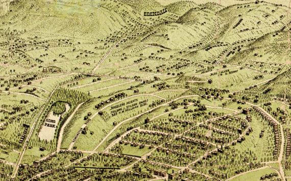
Set on the border of Elysian Park (which is the city’s oldest park, founded in 1886) were the 25 acres he purchased from J.B. Lankershim for $7,300. A $1,300 donation actual came from Alfred Solano, his namesake being, of course, nearby Solano Canyon. Walter was actually Solano’s step-son-in-law (Walter’s wife Marion’s mother was remarried to Alfred). Jarvis Street in Solano Canyon is likely named after Walter.

Anyways, enough about Walter. He created the Sanatorium to care for those people with turberculosis, a place for them to relax and get well. The site chosen for the hospital was a good one – a small valley protected the climate and provided clean air away from the bustling city nearby. Ironically, the Barlow Hospital website describes the location as wise because it was a “protective barrier against development.”

Most of the structures on the site (32 in all) were built between 1902 and 1952, and have been recognized as Cultural Monument No. 504. In addition to administrative and medical offices, there are quite a few patient bungalows with porches, dining rooms, laundry facilities, and recreation areas. If you’re walking South on Stadium Way from Scott Avenue, you can see these residential-looking structures on the right-hand side. You’ll also probably notice how dilapidated they are. Over the first few years, the hospital had enough room to house and care for 34 patients.

By the end of the 1970s, the focus on turbuculosis was no longer needed as TB became manageable and treatable, and instead concentrated on the treatment of respiratory diseases. By the 1980s, the hospital wanted to provide for AIDS patients by fixing up some of buildings that weren’t being used. Interestingly, the efforts came out of an organization that fought against a 1986 proposition that would have required a quarantine of AIDS carriers.

In 1988, the Chris Brownlie AIDS Hospice was opened at Barlow as the first AIDS hospice in California, and remained open until the mid-1990s. The two-story building where the hospice was had been home to around 1,500 patients.

The hospital has maintained its original philanthropic mission and continues to be a not-for-profit facility. It serves Southern California as a long-term acute care facility, focusing on rehabilitation goals such as weaning patients off of ventilators, and even home to the Barlow Respiratory Research Center. Currently, the hospital is seeking to sell of a huge portion of the land to fund the development of a new hospital, which it needs to do in order to comply with post-Northridge earthquake retrofitting requirements.

The future of the historic Barlow structures are uncertain, but we’ll be sure to keep you updated as they happen.

Our friends at the LA History Twitter page have reminded us that today is November 4! What the heck does that mean, you ask?

You guessed it: Oil!

Or maybe you didn’t. It’s kind of a weird part of LA History to embrace, but, as we wrote about recently, the very first oil well was actually here in Echo Park. It was November 4, 1892 when Edward Doheny and Charles Canfield dug this well at the site of what is now the Echo Park Pool. This discovery launched an oil boom in Los Angeles, so today is an interesting, and important, day in our history.

Currently, there are just a handful of oil wells compared to what it used to be (see photo of the Belmont oil field below). In fact, there’s a Google map Urban Oil Wells existing in Los Angeles – check it out by clicking here. To put things in perspective, here’s an 1906 map of oil fields in Los Angeles:

Source: Library of Congress

I’ve added the blue dot to indicate Echo Park Lake, the orange dot indicates the Los Angeles River (it’s a little tough to read). All the little black dots are oil fields (not just individual wells, oil fields).

Belmont Oil Field, date unknown

Photo by Echo Park Now

The Jensen’s Recreation Center building has always been a favorite Echo Park monument of mine. A historic cultural monument since 1998, the 86-year-old building has undergone quite a few changes inside.

The old bowling alley at Jensen's. Flickr photo via Mary-Austin & Scott

The building was built by German immigrant Henry Christian Jensen in 1924 and designed by architect E.E.B. Meinardus. Originally, it was a bowling alley with a pool hall at street level with 46 apartments on the other two floors. The Echo Park Historical Society website describes the space as catering to mostly males throughout the 1930s and ’40s. Even though the storefronts might not look exactly the same as the original structure, thankfully the Beaux Arts and Italianate inspired ornamentation that wraps around the outside of the building still exists.

The bowling alley is no longer there, but the sign featuring a bowling figure remains on the roof of the building. The 28 feet wide x 17 feet tall sign has 1300 red, green and white incandescent lightbulbs. An interesting fact: even though neon was a more popular application for signs in the 1920s (especially this size!), this one maintains the incandescent light bulbs.

Relighting of the sign. Photo from Paul Furlong

In 1997, after 50 years of neglect and the sign unlit, it was restored and relit through a cultural affairs grant. We’re not exactly sure how long the sign was lighting up the Rec Center roof, but we do know it was fixed and relit again in 2005. However, that lasted only one month, and the sign has been dark ever since.

Lately there’s been some great headway to relight the sign. The Echo Park Historical Society received $5,000 from an LA County Historic Preservation Society grant. Echo Park residents, fans of history, and Echo Park Improvement Association members have also privately donated to fix and maintain the sign as well. And just this week, the Greater Elysian Echo Park Neighborhood Council approved the allocation of $2,500 to the Historical Society for the restoration of the sign.

Hopefully we’ll see the sign relit (and maintained) some day soon!

If you’d like to donate to the Echo Park Historical Society for the restoration and upkeep of the sign, click here for the EPHS website.

The CCAC, photo from EPIAn Ways October 2000

A mention in the most recent Echo Park Improvement Association’s newsletter (EPIAn Ways) this month caught our interest – it’s been a whole ten years since the Central City Action Committee (CCAC) cut the ribbon on its current location in Old Fire Station No. 6 on Edgeware Road in Echo Park. Citing an article from the October 2000 issue of EPIAn Ways, the grand opening celebrated not only the organization, which organizes youth activities and graffiti removal in the area, but also displayed a “mini museum” of historical fire department photos. We thought we’d do some research on those photos and the history of Old Fire Station No. 6 for this week’s Flashback Friday.

Read more

Unknown date, possibly late 1930s. Source: Paul Furlong

More flooding in 1959. LA Public Library image #28410

We’re trying to piece together little bits of history surrounding photos like one shown above – flooding along Glendale Blvd. at Park Avenue was extremely common prior to the paving of the Los Angeles river. But how all that water got to Echo Park (remember, this is prior to all flood control in Los Angeles) is actually an interesting story.

The story starts with a buried river called the Arroyo de los Reyes, which originates off of Glendale Blvd. near the 2 terminus. It flowed down Glendale, to where Echo Park Lake now is, and into downtown down 2nd Street where it ends up just south of Pershing Square and eventually connecting to the LA River (Source: LA Creek Freak).

So it makes sense this area would be more susceptible to flooding – when it really, really rains, the creek/river would swell, and so on and so forth. We’re not sure exactly when the river was buried or why exactly it no longer floods Echo Park, perhaps due to being buried, but it might also have to do with the storm drain and flood control in the late ’30s, early ’40s.

The photo to the bottom right is a pretty severe flood on Glendale Boulevard during the Los Angeles Flood of 1938, caused by a couple of storms from the pacific and killing over 100 people and $40 million in damage.

Glendale Blvd., Feb 1938. Photo source: Paul Furlong

These floods, especially the 1938 one, prompted the Flood Control Act of 1941, and thus the construction of mandatory storm drains and flood control channels. This, of course, means the Los Angeles River was paved to help control future flooding.

Looking at these pictures, it seems like a good idea to have some flood control in Los Angeles. But the paving of the LA River is more and more criticized as being a misguided effort because it interferes with, well, the natural flow of things. There are some green movements to help the River filter out pollution and revitalize the river overall, you can learn a lot about lost rivers and creaks through the LA Creek Freak blog and the Friends of the LA River.