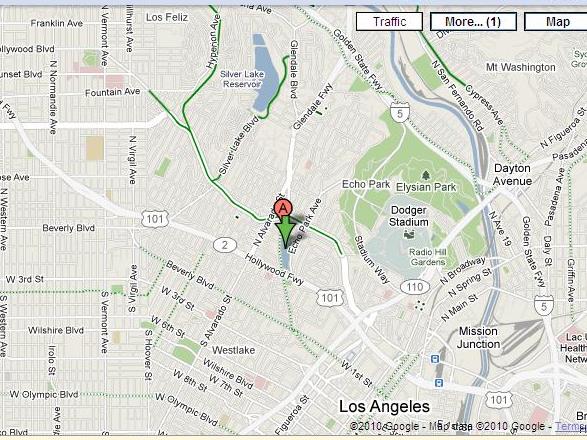
“Are you an avid cyclist or looking to ride your bike more often?” Google Maps took a step in a more bike-friendly direction about a month ago when they added biking directions as a transportation option. One can both get directions for traveling via bike and view which streets are safest for cycling. The project is still in the beta phase, however, and the directions and the suggestions for the best biking streets are not definitive.
But, as you can see from the map above, Los Angeles is not exactly Amsterdam. The green lines translate as follows: a dark green line indicates a bike path with no cars, a light green line indicates a street with a bike lane and a dotted green line indicates a street without a bike lane but which is less busy and safer for cycling. Google Maps also takes into account changes in elevation and suggests routes that don’t feature very steep streets.
There are several other resources out there for fans of two-wheeled transportation:
- LADOT has both a bike blog and a guide to biking in Los Angeles in PDF form that features rules, regulations and suggestions.
- LA Metro has a guide to biking routes in LA (pdf).
- Gmaps Pedometer is a great resource for cyclists who are also on a mission to burn calories. Just click on the map to create your own route. It will tell you how many miles you’ve traveled, how many calories you’ve burned (really?) and changes in elevation.
- On the second Friday of every month (along with a variety of other rides throughout the month), Midnight Ridazz organizes a night-time bike ride throughout Los Angeles.
- LA Streetsblog follows news and events in all things bike riding.
- Echo Park Cycles is, you guessed it, a local bike shop where you can get new gear or a tune-up. Prices are reasonable and the staff friendly!

